
I recently came across this fascinating world map while researching the history of the Jesuit missions in seventeenth century China. Apparently developed by the Italian Jesuit Giulio Aleni while he was working as a missionary in 1620s China, the map strikes me as being remarkably advanced for its time.
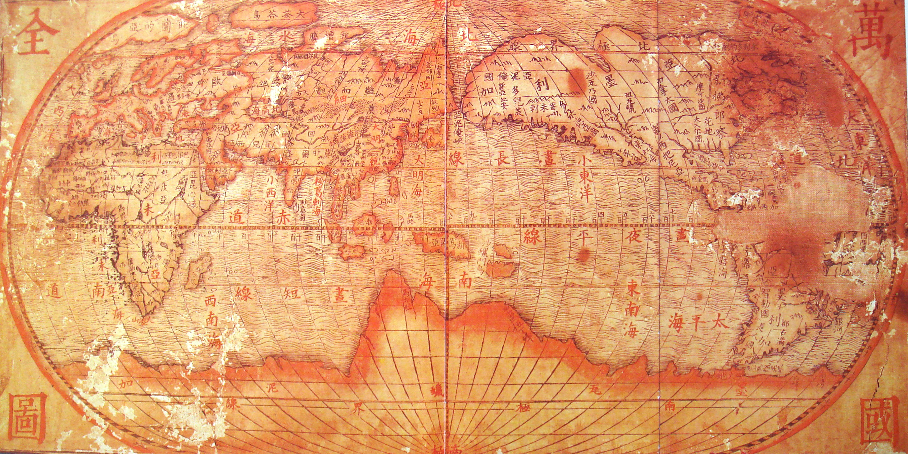
Witness, for instance, the fact that California is shown to be linked to the mainland of North America - portraying California as an island was a famous error of mapmakers of the seventeenth century and continued to be repeated by eminent cartographers up until the early years of the eighteenth century (for a few examples of these maps see here). Also interesting is the fairly accurate outline of the northern coastline of Australia embedded in an imagined southern landmass (the Terra Australis Incognita or 'Unknown Southern Land' of cartographic lore).
Perhaps the most telling difference between this map and its European counterparts is the Sino-centric nature of its orientation: here the Celestial Empire stands at the very center of the world map. If any of my readers happens to have any knowledge of Chinese characters, I'd be very curious to learn what the labels and captions say.
Luckily there is a slightly earlier Chinese world map, known as the Shanhai Yudi Quantu, that a Wikipedia user has generously gone to the trouble of translating.
Below is the original:
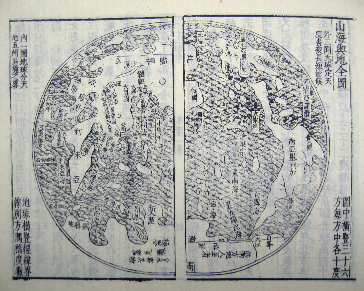
And here is the same map with translated captions:
[Edit, September 28]. I just came across an earlier Chinese world map, the Kunyu Wanguo Quantu or "Map of the Myriad Countries of the World," created by the famed Italian Jesuit Matteo Ricci in collaboration with Zhong Wentao and Li Zhizao in 1602. The Wikipedia page on it is quite good, and includes a remarkably detailed scan of this fascinating map. The full image seems to be too large to post here, but I've cropped a couple interesting details:
 |
| According to Wikipedia: The brief description of North America mentions "humped oxen" or bison (駝峰牛 tuófēngníu), feral horses (野馬, yěmǎ), and a region named Jiānádá (加拿大, Canada). The map identifies Florida as Huādì (花地), the "Land of Flowers." |


5 comments:
Actually, the "cross shaped character" has nothing to do with religion. It is a regular chinese character pronounced "ya". It was used as a phonetic here in the name of countries. For example, on northern Africa, you can notice from top to bottom, the three characters "利未亞". In modern chinese, this is pronounced Li Wei Ya, but at the time, the pronounciation was different and more like Li bi ya (Libya).
Fascinating! Thanks for sharing your knowledge. If you spot any other interesting transliterations please let me know.
I love this old maps, they make me wonder how they could understand their surroundings so well with the technology of their times!
this one in particular (the first one I mean) reminds me a bit of that map made by Muhammad al-Idrisi for Roger II of Sicily in 1154, that apparently was meant to be (once) all done in silver (or at least one of the copies).
well this was great, thanks a lot!
HI, thank you for this collection... I am searching for chinese mythology on islands - did you encounter any metaphors or stories about islands in ancient china?
Looking forward to some more details.
The source of early world maps supposedly came from Europe shortly after Columbus supposedly discovered America. It is impossible to a man who visited a few islands in the Caribbean to have done enough survey of the coastlines around the world to come up with such detailed maps. It wasn't until the time of Capt. James Cook the Europeans had enough knowledge for accurate maps.
The top Chinese world map on this page appeared to be influenced by European maps or was it? A copy of a world map supposedly originated from 1418 turned up at a Beijing auction that looked similar. By the time the Europeans started sending missionaries to China and established a base in Macau in the name of Portugal China was still in the Ming dynasty (the latter years). There are European influences on the Chinese maps. However, assuming the 1418 map was authentic, it becomes a question of the Chinese or the Europeans drawn the first world map?
Some curious features on the map: the names of seas and oceans were not translated directly from a European map. For instance, there are several labels where Pacific Ocean including: 太平海 "Sea of Peace" or Pacific Sea where the S. Pacific is located, 小東洋 "Little Eastern Ocean" where the N. Pacific is located and 大明海 "Great Ming Sea" for part of the Pacific adjacent to the coast of Japan & Taiwan.
And other odd features include 南極界線 "Southern Extreme Line" & 南極界線 "Southern Extreme" Chinese for Antarctica and above it 墨?泥加 mò?níjiā sounded like Chinese phonetic translation of the European Antarctica. Anyway, Antarctica was not discovered by Europeans until the 19th century so why is it in a 15th century map? The other odd feature is Australia not discovered until later by the Dutch ships to Java. There were a few islands in the S. Pacific. If 1 of these is supposed to be Australia, it is drawn too small and too far east.
Post a Comment